For 6,000 years the Mi’kmaq were the sole occupants of the area we know as the Shaubac, using it for hunting, fishing and portaging until 1604 when Champlain explored the area. In the early 17th Century settlers arrived from France, and they became the origins of our Acadian heritage. In fact, in 1632 Fort Point (across the LaHave River from Five Houses/Lower LaHave, and then known as Fort Ste Marie de Grace) was established as the first capital of New France.
The Shaubac area derived its name from the first person to own the land, Casper Shaubach. Around 1763 he was given the land by the British through a lottery as they were inviting Protestant Europeans (from France, Germany and Switzerland) to settle in the area. Although the French had already established colonies here and elsewhere in (what is now) Nova Scotia, recent fighting had given control of the lands to the English, and they decided that the best way to keep the land British was to populate the area with chosen immigrants.
Starting in 1753, these immigrants were offered land, food for a year, no taxes for ten years, guns and ammunition, and supplies for building, farming and fishing.
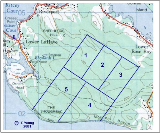
Much of the land along the eastern side of the LaHave River as well as elsewhere in the Lunenburg area was given out in 30 and 300 acre parcels. Of particular interest to the KCC at this moment are the five 300 acre lots awarded at that time in the Kingsburg Peninsula. Since then, all of the 300 acre lots have been subdivided several times into numerous smaller ones, ranging from 1 to 5 acres, with a few up to 35 acres in size.
There is no evidence that people ever lived on these 300 acre lots; instead, they were used for hunting, trapping, firewood, and resources for building such as lumber and stone. The map below shows these five 300 acre lots.
The map lines are only approximate, as each lot was the same in size (300 acres), nominally 800m x 1500m. Casper Shaubach was given #5, with #1 going to Johannas Riesser, #3 to Jacob Heyd, and #4 to Paul Mueller. #2 was identified as a Common Lot, but not related to the 450-acre Lower LaHave Commons (which was established in 1771 and shares a border with the Shaubac).
The Kingsburg Coastal Conservancy’s current project is to protect the area where Lot#5 and the west part of Lot#4 were located.